
The recent flooding Mon State has displaced thousands of people, killed nearly 70 people with many still missing, and has caused massive damage and destruction to houses and buildings. The death toll is expected to rise as recovery operations continue.
Rising water levels of the Ataran River in Kyaikmayaw Township, Mon State, has made 55,000 villagers victims of extensive flooding. More than 75 percent of the township villages (31 out of 47) sit submerged in flood water, according to official flood- damaged lists released on August 13.
Many small-sized boats are needed to assist villagers whose homes have been inundated by the flood. Those affected are also in need of emergency meals, potable water and food supplies.
However continuous rain is adding to the Ataran and Gyaing rivers that flow into the Thanlwin River. Local communities assume flooding will continue with the spring tides.
Meanwhile, 82 percent or 1,400 out of 1700 houses in Han-Gan village have been affected by the flood. Despite a reduction in floodwaters in Han-Gan, Ko-Mine, and Man-Aung villages, the water from wells, which is the main water source for villagers, is not yet safe to drink.
The Ma Yan, Chaung Na-kawa and Ah Pyaw bridges in the Ye Chaung Paya area, were damaged by the extensive flood. Strong currents swept away a house in Kin-Mon village. Flood waters blocked accessibility in many villages including Ka-Nee, Kyite Thin-Baw, Chea-Dite, Kin-Mon, Nay Paya, Mani Bura, Kyite Dine.
In the aftermath of the flash flood in Ye Township, villages are facing a great deal of damage to homes, including the loss of important documents like House Registration and Identity Cards.
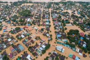
On August 11, the flood waters reached Shwe San Daw Pagoda, located in the heart of Ye town while nearly 80 percent of the town was covered by water.
The entire market on Strand Road, a Ye town landmark was flooded along with more than 1300 houses in 6 quarters/wards. Over 36,000 people have been affected by the flood.
On August 10 and 11, phone service in the area including those of Telenor, Oreedo, and MPT was either not functioning or severely hampered by the heavy rainfall and flooding.
The Mawlamyine-Dawei highway express route has remained impassable due to the landslide of Maloi Mountain, that occured on August 10. That landslide killed two people on the road.
On August 10 the rising water levels of the Ko-Mile stream washed away the track-bed under the railway track connecting Ye-Dawei around Mile Stone No. 276 (7/6). Also, the track between Ye and Mawlamyine remains closed due to bridge damage between Thanphyuzayat Township and Krote Pi village.
Also, water overflows from the salt field in Pa-nga has flooded the road between Pa-nga-Krote Pi and two relief camps that were opened in the area.
Flooding in Mawlamyine, Chaungzon, Mudon, Thanphyuzayat, Kyaikmayaw, Thaton and Belin along with other villages began on the morning of August 9. The lowland areas in Mawlamyine including Zaya Myaing, Thiri Myaing, Shwe Myaing Thiri, Pet Khin, Zay Kyo, and Strand Road were some of the first areas hit.
The collapse [landslide] of Ma Lat mountain in Thea Phyu Kone Village in Paung occurred on August 13 left at least 65 dead including eight non-local residents. 87 villagers were taken to the hospital, and one villager died while receiving treatment at the hospital. The village had 27 households with a total population of 169. During the August 9 landslide on the Yangon-Mawlamyine Expressway, 13 vehicles were trapped and destroyed. There are believed to be more people still missing.
Meanwhile, the landslide in Mann-Kyi village in southern Ye Township killed an orchid plantation owner and injured his wife who is receiving treatment at Ye Public hospital.
On the same day, almost half of the crushed stone roadway near the Wei-Win-Kayar Ah-Mor Nyi Naung Bridge on the Thanpyuzayat-Ye motorway was washed out by the flood waters. Thanbyuzayat -Three Pagoda Pass route remains impassable due to the 20 foot deep soil around Zin-Pyay Bridge having also been swept away by the flood. The Mudon-Chaung Na Kawa motorway was also cut off due to the damaged Kyat-Pha Bridge in Kyaikmaya Township, which links Kyon and Ka-Dah village. The temporary closure of the Yangon-Mawlamyine expressway also delayed traffic.
On August 5, over 200 houses in Ye, Chaungzon, Thaton, and Paung townships were devastated by strong winds.
During August 8 and 9, the water level from heavy rainfall in Mon State peaked at 28 inches. Mon State’s Chief Minister Dr. Aye San noted this is considered to be high for central Myanmar.
The heavy rainfall in August 2019 triggered one of the most hazardous natural disasters in Mon State among the four weather affected states/regions.
Meanwhile, people in the flood-hit areas of Kyarinnseikkyi, Kawkareik, Myawaddy, Hlaing Bwe, and Hpa An in Karen State have taken refuge in relief camps. Two quarters/wards in the Tanintharyi city along with 30 out of 64 villages were also inundated with floodwaters, forcing residents to leave their homes.
Sources/Credits; online news articles


